Labels

Cooking (53) Outdoors (32) Travels (44) Updates (36)

Wednesday, September 12, 2012

Zion: Hidden Canyon

We're talking Indian Jones.
(I know you're thrilled, mom.)
So much of your experience on this trail is determined by how far you go.

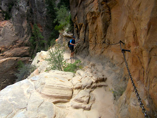
Hidden Canyon Trail is off of the main trail up to Observation Point (Weeping Rock Trailhead). It has some quickly ascending switchbacks that then lead to stone-hewn stairs and narrow ledges complete with chains mounted in to the rock wall as a handhold lest you slip a little on said ledges. After this obstacle course there is an unmaintained trail that will take you as far as you wish to go.

We wished to go just a relatively short way down the canyon to where there is a small free-standing arch. That became our turn around point.

Hike details (completed in conjunction with the Observation Point hike):
Total Distance: 2 miles (+ 8 miles on the Observation Point hike)
Total Time: It took us about 2 hours.
Hiked on Monday, September 10, 2012.


Hold on to your butts!


These roots were handholds over this slickrock incline.
This blogpost is the perfect opportunity to mention our friend with whom we traveled to Zion. He has a broken arm. It's in a cast-sling thing. The only thing it isn't, is duck-taped. At one point, as usual, our friend traveled ahead of us on his ridiculously long legs. We asked a group of people if they had seen our one-armed friend.
They said, "Yeah, he's standing at the top of a really big, slippery, steep rock."
Of course he is.
We made it!


Zion: Observation Point

What a hike. It was the perfect hike for our last day in the park. We started at Weeping Rock Trailhead and completed both Observation Point Trail and as far as we wished to go on the Hidden Canyon Trail. This post will be about Observation Point. 

The best way to describe it is to say that you gain 2100 feet in 4 miles. It is through the most beautiful areas and every time you round a switchback the view becomes better and better. Always fun was the brief part through the aptly-named Echo Canyon where you can, of course, play with your echo. You keep passing other trails - East Rim Trail, East Mesa Trail - wondering when you will find some sweet relief from the trail that just keeps going and going and going. When you do, though, it really is perfect. (Can I say that enough?) You can look straight down Zion Canyon, and even down onto Angel's Landing, another popular hike in the park. 


Hike details (completed in conjunction with the Hidden Canyon hike):
Total Distance: 8 miles (+ 2 miles on the Hidden Canyon hike)
Total Time: It took us about 5 hours.
Elevation Change: +2,148 net elevation gain.
Starting Elevation: 4360 ft. 
Ending Elevation: 6508 ft.
Hiked on Monday, September 10, 2012. 
 

J points out the mesa that includes Observation Point. The very south point of this mesa is the final stop on the trail.


Springdale, UT (Zion National Park)

J and I recently spent the 7th of September to the 11th of September in Springdale, UT. A friend of ours had rented a vacation home for the week and along with himself, J and I, and three other friends, we enjoyed the town and its gorgeous national park. These are just a handful of pictures taken around the vacation rental property...this was the lazy wine-soaked evening side of our water-drenched hiking days. We all cooked, cleaned, and hang out together when not on the trail. J and I even prepared our North African Fish Stew for the group. It's the third time we've made it now and it's always a hit.

For our hiking adventures in Zion you can follow these links:
The Narrows (Bottom Up)
Northgate Peaks (East)
Observation Point
Hidden Canyon

:)


Zion: Northgate Peaks (East)

The Northgate Peaks hike begins at the Wildecat Canyon Trailhead (you can also reach The Subway from this trailhead). We found it in one of the trail hiking books and it sounded rather fun. A shorter hike with awesome views into the valley - and it even ended on a lava rock outcropping. Very cool.

I googled it just to see if I would like the pictures and that's when I found the Protrails.com guide which explained how to go beyond the lava rocks, hack through to a social trail, and scurry up (quite quickly) to the top of the slickrock East Northgate Peak following nothing but cairns and stones laid out in arrows.

It was fantastic!

The first part of the hike to the lava trail is relatively easy. Starting at the Wildcat Canyon Trailhead you walk on the mesa passing the junction for the Hop Valley Trail. Shortly after that you will come to the Northgate Peaks Trail. It's a right turn on to that trail and you will now be heading south towards the gulch and canyon. From there the trail will take you all the way to the lava rock formation. Right before reaching it you will see gorgeous views of East and West Northgate Peaks and the Guardian Angel.

This is where we continued on, past the guide book and into the land of ProTrails. I did a little research and found that West Northgate Peak is considered a Class 3 scramble (it looked it!) and East Northgate Peak is a Class 2 Scramble. Or as I like to describe it: it's about 250 feet ascending relatively quickly on slickrock. :D

From the lava formation look to the left and find the social trail winding down towards the base of the slick rock. Once there, follow the cairns and stone arrows to the top. Just be careful; you will be rewarded!

 Hike details:
Total Distance: 5.1 miles
Total Time: It took us about 3.5 hours or so. Lollygagging.
Elevation Change: +528 ft round trip, 174 ft net elevation gain.
Starting Elevation: 6,985 ft. 
Ending Elevation: 7159 ft.
Hiked on Sunday, September 9, 2012.


Zion: The Narrows (Bottom Up)

This is my first of three posts about hiking in Zion National Park. On the first day we decided to attempt The Narrows due to the fact that the chance of rain increased as the days wore on and that trail become very dangerous and even can be shut down in the event of heavy rainfall. 
 
The Narrows can be completed two ways. The first is the top-down route which is about 17 miles long and can be completed in a day or two. The second is the bottom-up route which begins and ends at the The Temple of Sinawava Trailhead. In a day you can hike as far (or farther) as Big Springs. This takes you past Orderville Canyon and Wall Street. Our group of friends hiked as far as within 20 minutes of Big Springs but decided to turn around due to time and daylight remaining. I would love to do it again, only this time I would explore as far as the end of Wall Street and then turn down Orderville Canyon and explore as far as I could that way. We were not able to explore Orderville on this hike. 
 
To begin, one starts at an outfitting store and rents some bitchin' boots, complete with Neoprene socks. Super sexy.  Not to worry though, as they will be hidden under the cold water almost the entire time. And that cold water is going to feel mighty refreshing. Also for rent are walking sticks which were are an absolute lifesaver. There is even a waterproof backpack bag (we passed, but they were available). Why all this water preparation? The Virgin River is your trail. You will be in water, and you will be in water a lot.

After entering the park it's a shuttle ride to the trailhead of about 40 minutes. 
The first mile of the hike from the Temple of Sinawava Trailhead is paved and this is when you look the most awesomely awkward in your booties.
The next section is just under two miles and will find you at Orderville Canyon.
Within two miles of Orderville you will come to Big Springs, passing through the popular Wall Street section of the Narrows. 
Since we didn't quite make it to Big Springs we can't say that we hiked ten miles...except that we did walk from our vacation rental to the park, a distance of one mile. A perfect 10! I'd like to think we could also garner some extra points from hiking against the flow of water for 4.5 miles and then trying not to be swept off of our feet by its rushing underneath us on the way back. ;)

More pictures below!

Hike details*:
Total Distance: About 10 miles
Total Time: It took us about 6 hours, I believe. 
Elevation Change: Unknown for our section of the hike.
Hiked on Saturday, September 8, 2012.

*Unfortunately due to the fact that I have not yet installed MyTracks on my new phone I do not have a normal printout like I usually do of all of our statistics. I wish I had. That being said, the battery most likely would not have lasted for the duration of the hike and I would have been surprised if the GPS/location services could have kept track of us in the canyon.